Laser scanning, usually referred to as LIDAR (Light, Imaging, Detection And Ranging) works like radar or sonar, but uses pulsed laser light instead of microwaves or sound. In this article we'll describe how rugged tablet computers can play an important part in such system.
 Airborne laser scanning was initially developed in the 1970s by NASA and others in North America for the automated generation of digital terrain models. The technology came into its own when GPS and differential GPS became available, drastically increasing positioning accuracy. Once flying altitude and exact position is known, laser scanning technology can yield precise coordinates for the generation of two and three dimensional surface maps.
Aerial laser scanning is usually conducted from an altitude of roughly 3,000 to 4,000 feet above the surface. The accuracy of the scanning data, of course, depends on the surface consistency. Scanning solid ground, for example, results in maximum accuracy whereas scanning ambiguous surfaces such as forest canopies may require mathematical modeling and often a significant amount of post-processing.
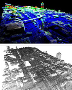 Aerial laser scanning can also be used in urban area modeling where the scan data can be used to create very accurate 3D city maps and architectural representations, often in conjunction with ever more detailed photographic imaging data.
In fact, current development efforts combine digital imaging with laser scanner data in various ways. Other applications include as-built surveys of infrastructure and complex building systems, archaeology, as well as accurate assessments of demolition, flooding, crops, and so on. The possibilities are almost endless.
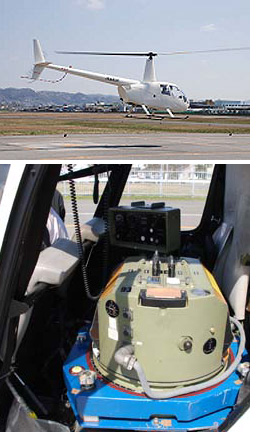
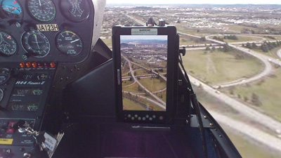
While aerial laser scanning surveys and numerous other LIDAR projects are being conducted around the world by governmental as well as private entities, there is an increasing number of smaller businesses that offer such scanning and surveying services. One of them is Aero Sensing, Inc., of Osaka, Japan. For the past five years, Aero Sensing has been providing aerial laser scanning and surveys, aerial photography, as well as a variety of spatial and geographical data collection services. Survey missions are conducted in Robinson R22 and R44 helicopters as well as a Cessna 206 Stationair single engine plane.
As in all airborne operations, weight is an issue. Onboard equipment must be light but tough, and be able to handle the pressure differences inherent in small craft air travel as well as shock and vibration, which can be considerable in choppers. In addition, aircraft use mandates display viewability under a very wide range of ambient lighting conditions, ranging from bright sunlight all the way to night flight operation. Aero Sensing requirements for an onboard tablet computer were:
- Small and light enough to be mounted in a helicopter or single engine aircraft without materially impacting payload or operation.
- Touch screen to remain viewable and readable even in direct sunlight but dimmable enough for lowlight conditions.
- Display to be large enough to be easily viewed and used, but not so large as yo get in the way in a cramped cockpit
- Rugged enough to handle shock, vibration, temperature extremes as well as dust and water and other environmental as outlined in MIL-STD-810G testing procedures.
Aero Sensing ended up using the Samwell RUGGEDBOOK SR820 tablet computer (see picture above), which has a 8.9-inch daylight-readable display that is large enough to show a wealth of imaging information, but not too large to get in the way in a chopper. IP65 sealing also means the unit is largely immune to dust, rain and weather, and the device has passed numerous environmental tests, including shock and vibration.
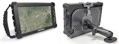 The Samwell RUGGEDBOOK SR820 provides Windows functionality and performance in a rugged, fanless tablet form factor. Measuring just 10.1 x 6.2 x 1.5 inches and weighing under three pounds, the SR820 is smaller and lighter than full-size rugged tablets without requiring many compromises. There is good wired connectivity on board, all the connectors are standard size, and there is a wealth of wireless functionality (including available GPS and 3.75G radio) and also an integrated camera and optional laser scanner. The device can easily be carried and just as easily mounted in aircraft (or any other vehicles) via standard VESA mounts (shown with RAM-Mount ball-and-socket mounting system).
Relevant Information:
Samwell Group RUGGEDBOOK SR820 page
Aero Sensing, Inc. website
Wikipedia page on LIDAR
To learn more about the ruggedized Samwell SR820 tablet computer and its many applications, email RUGGEDBOOK at info@ruggedbook.com.tw. And check RuggedPCReview.com's full analysis of the SR820.